Mt Harmukh and the Discovery of K2
DISCOVERY OF K2-8611M
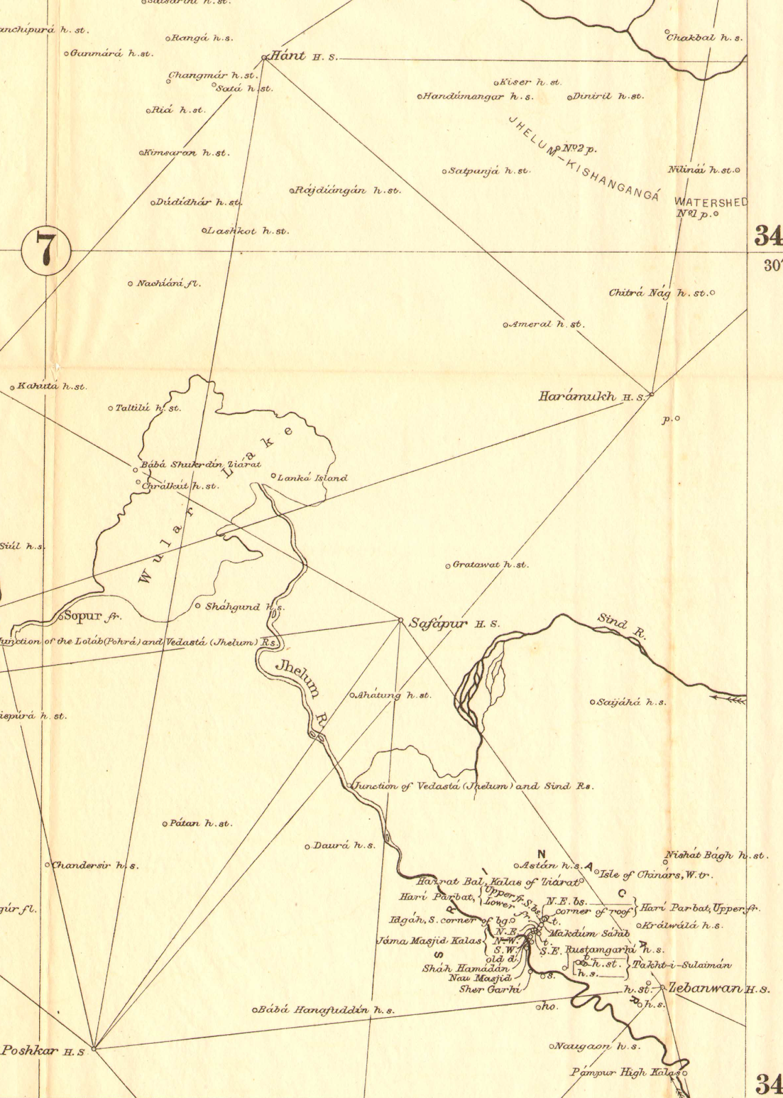
Mt. Haramukh
A mountain mass towering up above the Walur lake on the NE side of Valley, lying almost due North of Srinagar. It is the most striking mountain mass rising like a giant above the ranges. The lowest of the peaks is a conical mass of rock, which was used for Survey purposes and is known as the "Station Peak (4877m)," and can be fairly easily approached from the west by a long rocky ridge. The other summits are the Western, Middle, Northern(4961m), and Eastern(5142m). The last, which is the highest of all, is separated by a gap, 400 feet deep, from the rest of the mountain. On three sides-namely, the north, east, south-there is a deep snow cornice, resting on a sheer rock precipice that drops about 3000 feet to the upper edge of the Gangabal glaciers.
Discovery of K2, the world's second-highest mountain
After the defeat of Sikhs in 1846, there was a call for triangulation to be carried out into Punjab to control military and revenue surveys. The Kashmir triangulation was started by Montgomerie in 1855 from the neighborhood of Jammu and extended across the Pir Panjal to the great Himalaya range fixing the peaks of Nanga Parabt and K2. His immediate task was to set out a chain of triangles starting from the main series about 20 miles east of Jammu and working it across the Pir Panjil range to the Kashmir valley.
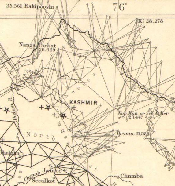
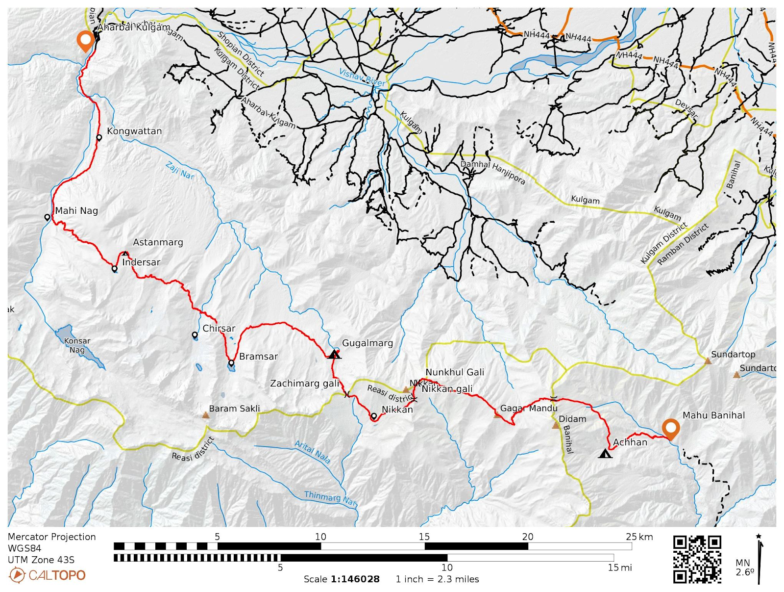
Minor Mountain Triangulation executed by Kashmnir survey and NW Himalaya series. (Zoomed view)
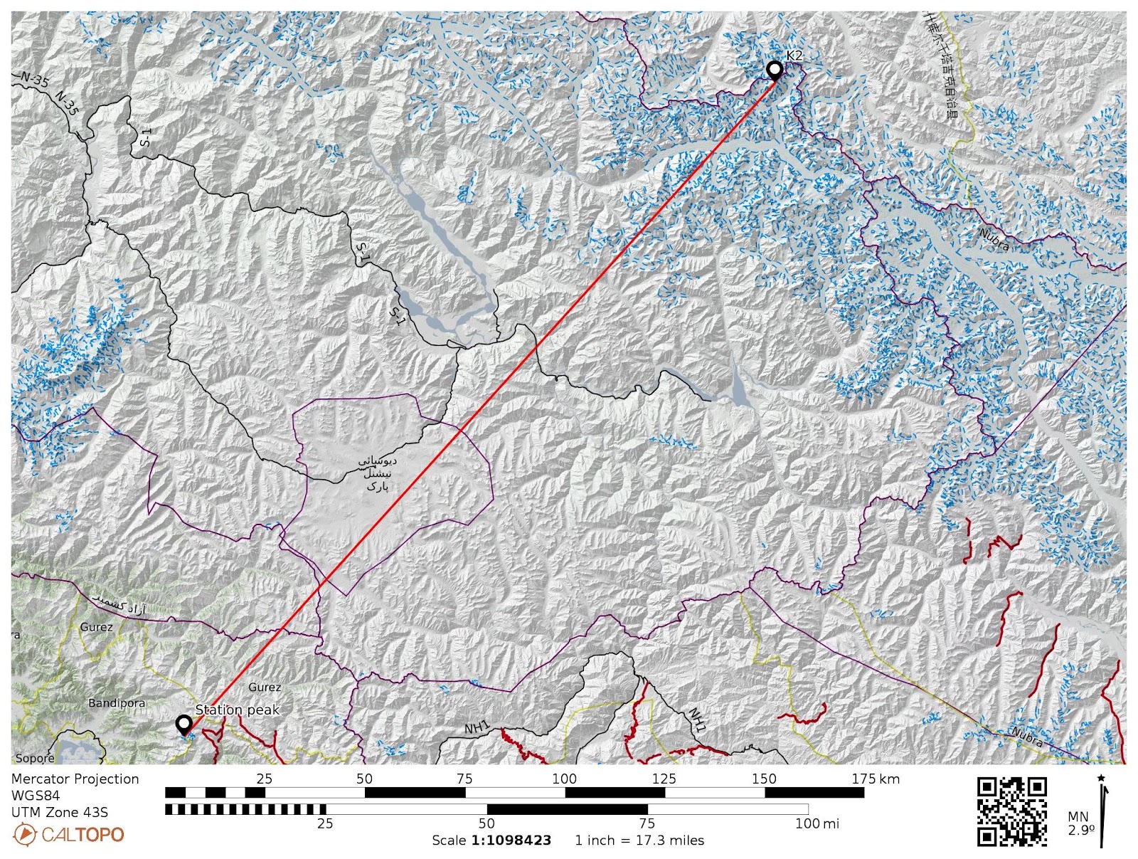
Much of the reconnaissance was done by him personally, and it was from the survey station at Haramukh, which stands north of the Sind valley towering above Gandarbal, that he, in 1856, first saw the giants of the Karakoram. The station of Haramukh is upwards of 16000 feet above the sea, commanding a fine view of 270 degrees of the horizon. The platform is just above a fine glacier that slopes down into a tarn called Gangbal.
In the following year, George Shelverton first observed them from the same station, and in 1858 the great pyramid of K2 was computed at 28,250 feet, so displacing Kangchenjunga to third place. In these observations, thirty-two peaks of the distant Karakoram were observed. They were recorded as K1, K2, K3, etc., up to K32. No names could be given to them at the time, and some have none. Nineteen of them are above 25,000 feet and, of these, six are over 26,000 feet.
 |
| From Leh Srinagar flight, K2 (left), Broad Peak, Gasherbrum peaks, etc by Haziq Beigh. |
Captain Montgomerie in his report writes,
“On the 6th of Sept, I commenced the ascend of the snowy mountain of Haramukh. After a march of 4 days, I reached the station that Mr. Johnson had built before the rains set in. I encamped on the summit leaving, however, the bulk of my camp just below the limit of forest. This station is built on a sharp spur of the snowy peak of the same name. It is some hundreds of feet below the top of the peak. The highest point was abandoned partly in consequence of the refusal of the carriers to cross over the cracks of the glaciers that intervened between it and the present station and partly because it was too exposed a situation for the lamp men. This station can be reached from Bandipora on the great lake in 4 days and is about 16 miles to the east of Bandipoor.
 |
| Summits of Harmukh from the Gangbal valley. ( Photograph and labelled by Adil Shah) |
During my three-day residence on the snowy mountain Haramook, I had the pleasure to see the various ranges of the Himalayas right up to Karakoram. There was nothing remarkable in the first 6-7 ridges. Beyond came the snowy points of the Karakoram range and behind them, I saw two fine peaks standing high above the general range possibly 140 miles away from me. Amongst others, two very fine peaks were visible beyond the general outline of the Mustagh and Karakoram ranges. These two peaks promise to be high; they were but faintly defined against the sky, being probably about 150 miles from me. By two o’clock on the first day, I had drawn out all heliotropes on the other peaks except one, and that made its appearance in time to allow me to take two zeros before the sunset on 2nd day.”
He dubbed these two peaks K1 and K2, but no second shot was got to them until July the following year when Brownlow observed them from stations further North and the height of K2 was found to be some 28,000 feet.
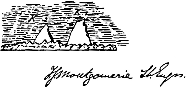
Montgomerie's sketch of K1 and K2. K2 appears smaller than K1 due to it being the furthest away peak.
The high western pinnacle of the Karakorum range was first seen and observed on the 10th and 11th of September 1856 when he made the sketch in the margin of his angle book. He got the horizontal bearing to K2 on each day and two vertical angles on each face between 1 and 2 o’clock on the afternoon of the 10th. Mr. Bronlow, who carried the principal triangles forward across the Deosai Plains during 1857, got both horizontal and vertical angles from stations of Kanuri Nar, Barwai, and Thalanka on the 17th of July and 26th of August. These observations, combined with those taken from Haramukh the previous year, enabled Montgomerie to fix the position of K2 with a preliminary height of 28,400 feet.
 |
| Results obtained by Montgomerie from observations taken by Brownlow |
In his instructions to Shelverton and Johnson for observing along the Indus between Skardo and Leh, Montgomerie directs the principal vertical observations are to be taken on each face between 1 and 4 p.m. and every day, if weather permits.
All snowy peaks to the north of the river Shyok, and to the north of the Indus below the junction of the Shyok, will be denominated K11, K12, etc. All other peaks are to be called B 19, B 20, etc. Time must be noted when verticals are taken to the snowy peaks. The clouds rarely permit the snowy peaks to be seen afternoon, but it would, of course, be advantageous to take them near minimum refraction. Peaks to the North-East of the Indus are to be called I1, I2, etc., and those peaks at the head of the Indus are to be called R1, R2, etc. All peaks to the south of the Indus on the Zanskar side are to be called Z1, Z2, etc.
With his report for 1860, Montgomerie appends a list of major peaks fixed up to that season, to which the 1955 heights are here added in brackets.
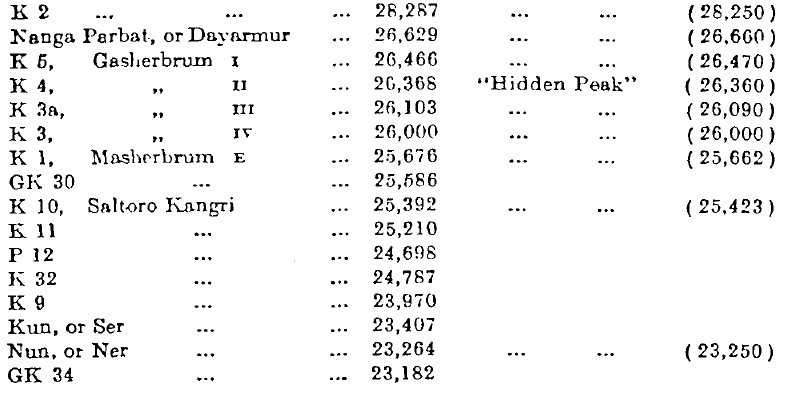
After further observations by George Shelrerton, 1858, and William Johnson 1859 Montgomerie reported that the height of 28,287, the mean of several results, will probably not alter much when all the refinements of computations have been applied. The peak may therefore be considered the second highest in the world. Several other peaks have been found to be more than 26,000 feet above the sea.
Naming the K2
The surveyors found no reliable name for this gigantic peak but, writes Montgomerie, "every endeavor will be made to find a local name if it has one ". His little sketch from Haramukh suggests an explanation, for K1 though 2,600 feet lower is here by far the more prominent, and has the local name of Masherbrum. In 1931 Burrard points out that the great peak had become locally recognized and called "Kaytoo or Kaych”. The lack of a widely used local name was probably due to its remoteness. The mountain is not visible from nearby habitations and is only fleetingly glimpsed from the end of the Baltoro Glacier, one of the longest glaciers in the world outside the polar regions, and few would have ventured beyond this point. Many names have been proposed, Mount Waugh and Mount Alberts were considered in 1860. Mount Montgomerie and Mount Godwin Austen were suggested about 1886. Mount Akbar and Mount Babar were names considered in 1905-6, but none of these names met with general approval.
The best-known of Montgomerie's assistants was Captain H. Godwin- Austen. He first discovered and surveyed the great system of Karakoram glaciers in 1861, including the Baltoro glacier approach to K2. He was probably the greatest mountaineer of his day. But, though he was a great mountaineer, K2 was not discovered by him and is not named after him. In 1888, General J. T. Walker, at a meeting of die Royal Geographical Society in London, proposed that K2 should be named after him. But the suggestion was not approved by the R.G.S, the Survey of India, or the Government of India.
In 1930 a conference on the geographical names of the Karakoram region was held in London, at which the Royal Geographical Society and the Surveyor General of India were represented, and this conference endorsed the name K2.
The Kashmir Survey was completed in 1864. In 1865 Montgomerie was awarded the Founders Gold Medal of the Royal Geographical Society for his great trigonometrical journey from the plains of Punjab to the Karakorum Range.
References:
1. Great figures of nineteenth‐century Himalayan exploration Lieut.‐Colonel Kenneth Mason.
2. SURVEY OF KASHMIR AND JAMMU,1855 TO 1865 By COLONEL R. H. PHILLIMORE, C.I.E., D.S.O.
3. Synopsis of the results of the operations of The Great Trigonometrical Survey of India (NW Himalaya series) by Major General J T Walker, surveyor general of India.
4. Historical records of Survey of India by Phillimore.
5. Nanga Parbat and snowy mountains of the Himalaya range bt T. Montgomerie.
6. On trigonemtrical survey of the valley of Kashmir by Purdon.
7. Survey of Kashmir under Montgomerie.
8. Memorandum on the Progress of the Trigonometrical Survey in Kashmir

Triangulation of NW Himalaya series ( Sheet 7)
Triangulation of NW Himalaya series ( Zoomed view)

From Leh Srinagar flight, K2 (left), Broad Peak, Gasherbrum peaks, etc by Haziq Beigh.


Comments
Post a Comment