Posts

Mt Harmukh and the Discovery of K2
Image
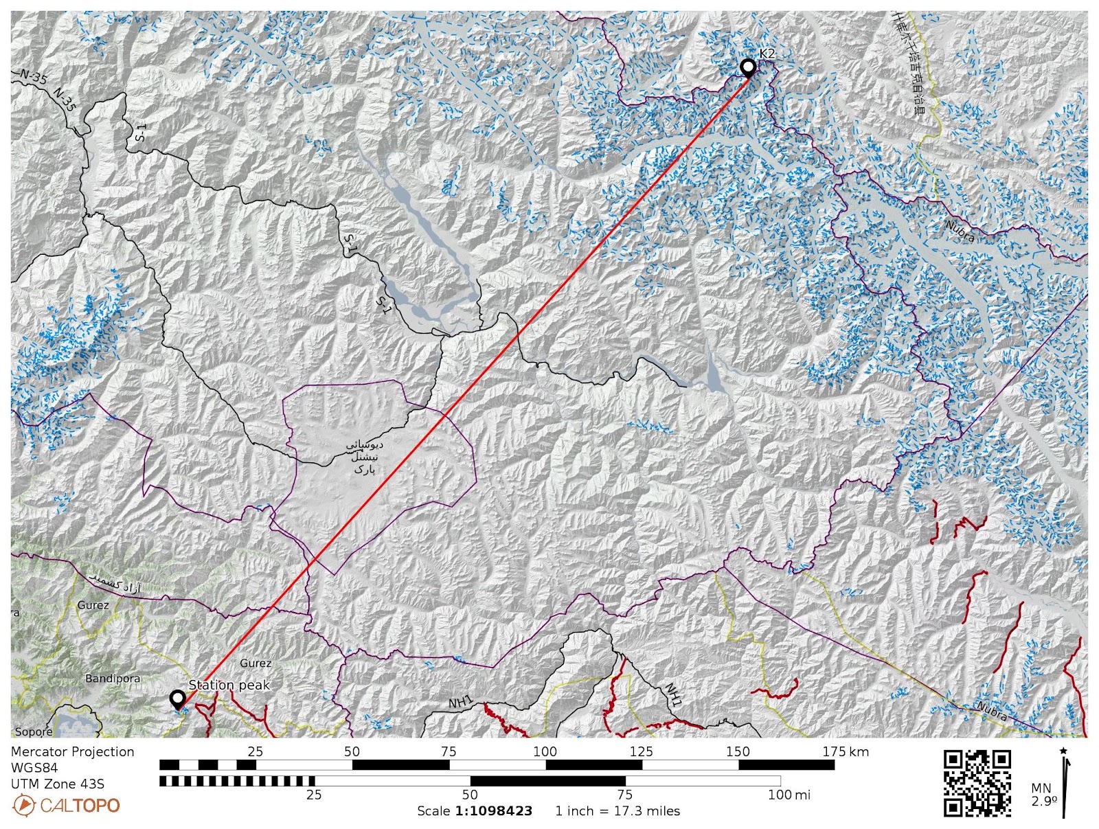
 DISCOVERY OF K2-8611M Mt. Haramukh A mountain mass towering up above the Walur lake on the NE side of Valley, lying almost due North of Srinagar . It is the most striking mountain mass rising like a giant above the ranges. The lowest of the peaks is a conical mass of rock, which was used for Survey purposes and is known as the "Station Peak (4877m)," and can be fairly easily approached from the west by a long rocky ridge. The other summits are the Western, Middle, Northern(4961m), and Eastern(5142m). The last, which is the highest of all, is separated by a gap, 400 feet deep, from the rest of the mountain. On three sides-namely, the north, east, south-there is a deep snow cornice, resting on a sheer rock precipice that drops about 3000 feet to the upper edge of the Gangabal glaciers. Discovery of K2, the world's second-highest mountain After the defeat of Sikhs in 1846, there was a call for triangulation to be carried out into Punjab to control military and revenue surve...
Astanmandu Baihk and Hiramarg trek

Image
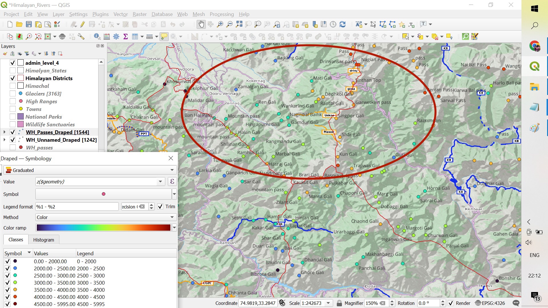
Exploring SE Extremity of Valley By the SE extremity, i mean the area between Banihal range from Doru Verinag upto Sinthan pass. There is so much of  potential in this sub 3500m  regions of Kokernag, Daksum, Garol, Doru Verinag and surrounding regions. These regions are separated by the long spurs of main mountain range surrounding the valley from SE. Map showing the surrounding hills and passes. Sunday, 08-01-2023 As usual, we left our homes early in the morning towards the hamlet of Matti in the Kokernag tehsil of Anantnag district. The hamlet is at an elevation of 2200m and we started our hike towards Hiramarg Baihk which was at an elevation of 3300m. The ascent was inclined from the starting  and the route winding through the dense forests mainly ...

Thajiwas - Valley of Rocks and Glaciers

Image
 Thajiwas Thajiwas valley is a famous beauty spot in Sonamarg and the  Thajiwas Range, overlooking it, is as fine a range as any of like size in Kashmir. It runs SE to NW and joins the Sindh river at Shitkari just below Sonamarg where the westward flow of the river is turned South to the Vale of Kashmir.  The overlooking igneous Thajiwas range is by no means a cragman's paradise. It affords some varied and arduous climbing and for those who are found snow and ice work, it is an excellent playground. The range culminates in 4854m Thajiwas peak and between the ridges are six fairly well defined hanging glaciers  which are steep, harder of ascent than average alpine glacier. Glacier 1 overlooks the Sonamarg and is directly under 4854m Thajiwas peak. The Thajiwas peak was first climbed by J. Waller in 1937. It was his second attempt to this peak and were successful in reaching its summit via a 300m Couloir which was later named as Waller's Couloi...

Tatakooti Peak (4750m) | First Civilian summit | Sept 2022

Image
JKMAC Tatakooti Expedition - Sept 2022 Team JKMAC at the summit A nine-member team of JKMAC summited the Tatakooti peak of Pir Panjal Range, marking the third successful summit of the peak. Distance Covered : 37.57 km  Highest altitude : 4750 m (garmin) Team leaders : Mr Gh. Mohammad (Gullu) and Mr Arashid Majid. Members : Gullu, Arashid Majid Taous Baba, Haziq Beigh, Zeeshan Mushtaq, Mudasir Bashir Shah, Khursheed Beigh,Ahsan Mohsin and Tanveer Dar. A brief history: Tatakooti peak lies on the South Western side of the Kashmir Valley and is the highest peak of Pir Panjal Range, bounding the valley from South West. Dr Ernest Neve, a renowned mountaineer and medical missionary officer, in his book Beyond the Pir Panjal describes the peak as “ the most conspicuous and imposing of all the peaks of Pir Panjal range is undoubtedly Tatakooti peak, the pyramidal shape of which with a central notch and very steep and jagged western and northern sides, makes it look as if it might be exceed...

Hirpora Lakes trek | Day1: Dungimarg Mughal Road to Handu Sar.

Image
05 Aug 2022 | Pir Panjal Range Topo sheet along with route and terrain details Far towards the South western end of the valley, around Pir Ki gali, there are dozens of alpine lakes within 3-4 km of radius. Some of them fall in Kulgam district and some in Poonch and Rajouri districts of Jammu & Kashmir and accordingly there are many routes from these districts to explore all of them.  I started my journey from Kashmir division and m inimum of three days is required to explore the whole area. Jaddi nar valley On 5th of Aug 2022, I with my friend Muhammad Zahid left from Srinagar towards Dongimarg, Mughal road, some kms before from Pir ki Gali and parked our car near the wildlife dept. At around 8am in the morning we left from Dungimarg, crossed the Yanga nar stream which at Sokh Sarai is joined by Rupri Nar and forms the Rambiara river, a tributary of Jehlum river. Chandan Sar T...

Pir Panjal traverse - Day2: Achhan to Gugalmarg

Image
31st July 2022  I stayed for the night with bakerwals at Achhan  and it was raining all night. At about 8am in the morning i left the tent after having some noodles and tea. I moved towards Saranjan and crossed a 3850m pass North of Didum peak(Hoen Heng), SW of Chakiali gali which connects Mahu Banihal with Kandimarg Kulgam.  View SE from Saranjan I descended down 200m into Sikwas Nala valley and climbed again to the main ridgeline of Pir Panjal range, NW of Gagarmandu peak(4000m). The top ridgeline separates Kashmir and Jammu division. I then followed the 3900m contour and traversed the ridgeline upto Nikkan gali where I descended 150m down to Nikkan. Top ridgeline of Pir Panjal range On way to Nikkan gali, i explored Mang nar valley, traversed Nunkhul gali which connects Kulgam and Gulabgarh. It was a cloudy weather and as soon I reached Nikkan, it started to rain and i took shelter at Shepherds camp. After 15min the weather got cleared and i left  and entered bac...

Pir Panjal traverse - Day1: Mahu to Achhan

Image
Pir Panjal is a basaltic mountain range that bounds the Kashmir valley from South. In the December of 2021, while mapping the peaks, passes, nomadic dwellings and hiking routes on this range in OSM, i planned to traverse the entire range from Banihal To Tangmarg in a single continuous stretch  but unfortunately i had to end it at Aharbal Kulgam.  30th July 2022 - Day1 I took a first train from Srinagar to Banihal at 8:07am and it almost takes two hours to reach there.  I had to reach Mahu valley where from the journey begins. I took a cab from the main market to Mahu and due to bad condition of road and landslides, it took about 3 hours from Banihal to Mahu valley.  This place is really a hidden gem and has a lot of potential for hiking and adventure tourism. Enroute to Mahu valley. At about 2pm, after having lunch and praying Zuhr at my friends home, i left for my journey. On way towards Achhan, there is an army camp about 1.5kms from the village. I proved my ident...